Diagenesis
Diagenesis: In geology, diagenesis refers to the physical and chemical changes of a sedimentary formation when compaction and lithification occur over time.
Diagenesis: In geology, diagenesis refers to the physical and chemical changes of a sedimentary formation when compaction and lithification occur over time.

Geologic Time Scale The Geologic Time Scale is an international system used by geologists to classify and identify major geologic events and formations. The geologic timescale essentially categories the earth’s entire geologic (and biologic) history, within a series of defined eons, eras, periods, epochs, and ages. Updates & Maintenance The geologic time scale is continuously…
Petroleum Extraction Well (Oil Well) Petroleum Extraction Well (Oil Well): A petroleum extraction well, or an oil well, is a deep borehole or shaft sunk into the Earth for the exploration of oil or gas. Additionally, injection wells are often drilled to inject fluids or gas for stimulating oil recovery, re-pressurizing or pressure maintenance of…
Transgression Transgression: In geology, the term transgression is the formation of a specific sequence of sedimentary and metamorphic layers, that are the result of ocean water advancing onto land. To illustrate, when transgression occurs over millions of years, geologists find a layer of sand, overlain by shale, and overlain again by limestone. The opposite of…
Environmental Geology Environmental Geology: (en·vi·ron·men·tal ge·ol·o·gy) a branch of geology that relates to the impact of human activity on Earth, and the pollution of geologic formations, reserves, and resources. Common focus points of environmental geology are contaminated soil, groundwater aquifers, lakes, rivers, and the ocean. Professional geologists assess and remediate contamination plumes in all media,…
De-Watering System in Methane Mitigation De-Watering: In accordance with the Los Angeles Department of Building and Safety (LADBS) Methane Code, Ordinance Number 175790, a de-watering system is a permanent water removal system in a methane mitigation system. In the mitigation process, a de-watering system consists of perforated horizontal pipes, gravel pockets, sump areas with pumps,…
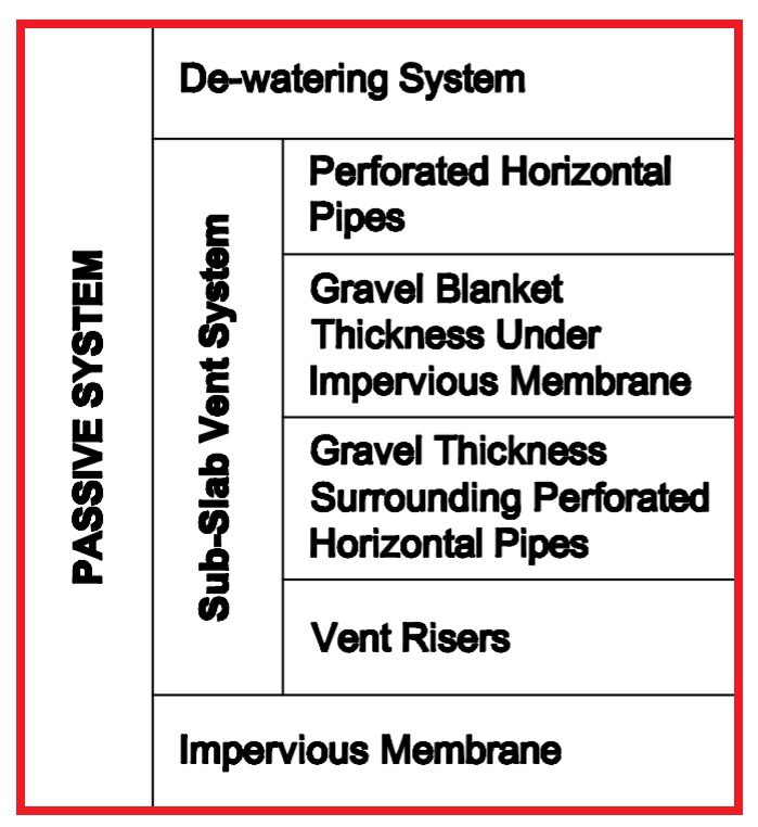
Passive Methane Mitigation Passive Methane Mitigation: Passive systems refer to the non-mechanical and non-electric components of the methane mitigation process. These components remove the vapor intrusion risks of methane soil gas migration into buildings atop Los Angeles Methane Zones and Methane Buffer Zones. In fact, methane testing results typically indicate the necessity for a passive…