Control Panel for Methane Mitigation System

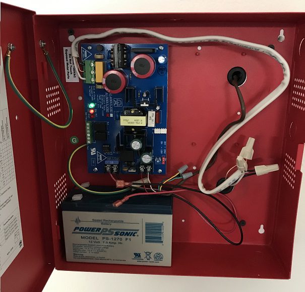
Control Panel in a Methane Mitigation System

Control Panel of a Methane Mitigation System: A methane mitigation control panel is the brain behind the active mitigation system. In accordance with the Los Angeles Department of Building and Safety (LADBS) Methane Code, Ordinance Number 175790, a control panel synchronizes methane alarm units with sensors and the active ventilation systems on-site. For instance, the control panel of a methane mitigation system activates the sub-slab soil vapor extraction system and HVAC system when high levels of methane soil gas occur.

Alarm and Detector Control Panel and Backup Battery Methane Mitigation System

Similar Posts

  • Unconfined Aquifer

    Unconfined Aquifer Unconfined Aquifer: In the hydrogeology branch of geology, an unconfined aquifer is an aquifer that has a water table. In fact, an unconfined aquifer can only be the uppermost hydrogeologic unit and is particularly one that has no hydraulic head (or pressure) that is equal to atmospheric pressure. To illustrate, depth to groundwater…

  • Licensed Professional Geologist

    Licensed Professional Geologist A “Licensed Professional Geologist” or a “Certified Professional Geologist” is a person who is certified by a State and/or Federal agency (such as the California Department of Consumer Affairs, Board for Professional Engineers, Geologists & Land Surveyors), and has proven be educated, formally trained and professionally competent per government standards, to practice…

  • Fault Scarp

    Fault Scarp Fault Scarp: In the field of geology, a dip-slip fault scarp is a steep slope that is formed directly by fault movement. It occurs along the line of a normal fault, reverse fault, or transform fault. A fault scarp represents the planer surface of the fault before erosion and weathering modify it.

  • Geosyncline

    Geosyncline Geosyncline: In geology, a geosyncline is a large-scale indentation in the Earth’s crust that is filled with sediments. A geosyncline forms due to the gradual sinking of the Earth’s crust, causing sediment from adjacent areas to gather inside. An example of a geosyncline is the Appalachian Mountains.

  • Water Table

    Water Table Water Table: In the hydrogeology branch of geology, the water table represents the surface of an unconfined groundwater aquifer, where the hydraulic pressure is equal to atmospheric pressure. Additionally, a water table is present in a perched groundwater zone. Although, there is no water table in a confined aquifer.