Similar Posts
Listric Fault Definition
Listric Fault Listric Fault: In the field of geology, a listric fault refers to a fault with a curved fault plane. Most listric faults comprise a steeply dipping section near the surface. But the fault plane becomes increasingly flat with depth. Listric faults can be normal faults or reverse faults.
Mineral
Mineral Definition A mineral is defined as an inorganic element, compound, or substance that naturally develops with an organized internal structure and/or crystal form over time. Minerals are also distinguishable by their chemical composition and physical properties, as determined in laboratories by geologists. Typical earth minerals found in most igneous, metamorphic, and sedimentary rocks are…
Thermosphere
Thermosphere Thermosphere: The thermosphere of a terrestrial planet is the fourth and final member of the atmosphere. On Earth, the thermosphere starts atop the mesosphere at approximately 85 kilometers above mean sea level. The upper limit of the thermosphere is reasonably presumed to terminate approximately 95 kilometers above mean sea level. In fact, most of…
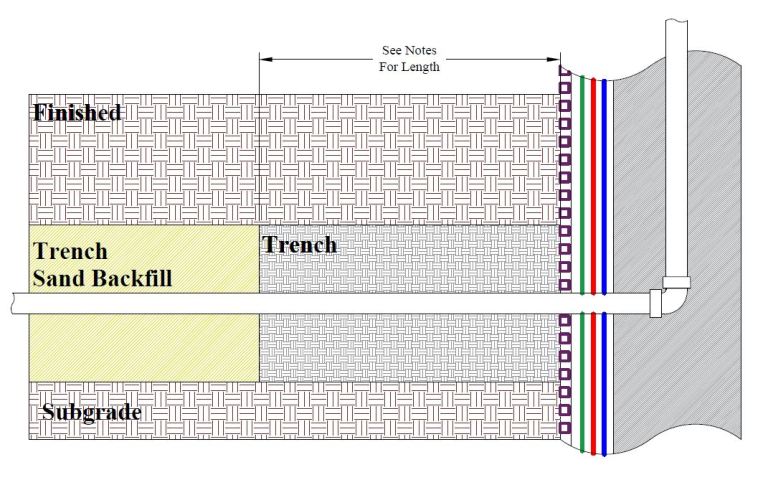
Trench Dam
Trench Dam Trench Dam: Per the Los Angeles Department of Building and Safety (LADBS) Methane Code, Ordinance Number 175790, a trench dam is part of a methane mitigation system. A trench dam is essentially a subsurface barrier that exists within a furrow or ditch, that is adjacent to the foundation of a building in a…
Epicenter
Epicenter Epicenter: In the seismology branch of geology, an epicenter of an earthquake is the point on Earth’s surface that is directly above the focus (or hypocenter). It is the ground surface location overlying where an earthquake rupture originates within a dip-slip fault or strike-slip fault. Shortly after an earthquake, United States Geological Survey (USGS)…