Sand Boil
A “Sand Boil” is a cone-shaped deposit of sand that is formed during an earthquake. A Sand Boil occurs when subsurface sand layers liquefy and are then blown to the surface through cracks.
A “Sand Boil” is a cone-shaped deposit of sand that is formed during an earthquake. A Sand Boil occurs when subsurface sand layers liquefy and are then blown to the surface through cracks.

Thermosphere Thermosphere: The thermosphere of a terrestrial planet is the fourth and final member of the atmosphere. On Earth, the thermosphere starts atop the mesosphere at approximately 85 kilometers above mean sea level. The upper limit of the thermosphere is reasonably presumed to terminate approximately 95 kilometers above mean sea level. In fact, most of…
Extrusive Rocks Extrusive Rocks: In the volcanology branch of geology extrusive rocks are igneous rocks that have been erupted onto the Earth’s surface, before forming and crystallizing. On the other hand, intrusive rocks form and crystallize under the Earth’s ground surface. Extrusive rocks are typically microcrystalline and aphanitic, because of the faster rate of cooling…
Mineral Assemblages Mineral Assemblages: In the field of geology and the branch of mineralogy, the term “mineral assembles” means the minerals that compose a rock, including the different kinds and their relative abundance.
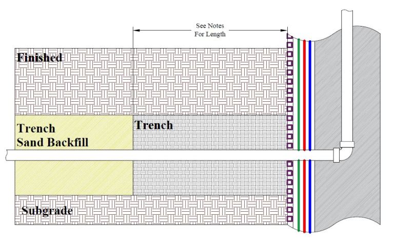
Trench Dam Trench Dam: Per the Los Angeles Department of Building and Safety (LADBS) Methane Code, Ordinance Number 175790, a trench dam is part of a methane mitigation system. A trench dam is essentially a subsurface barrier that exists within a furrow or ditch, that is adjacent to the foundation of a building in a…
Effective Size (D10) “Effective Size” (D10) is an engineering geology term. Effective Size represents a diameter that directly corresponds to the percentage, by weight, of grains that equal to 10% on the grain-size diagram. To illustrate, 10% of the soil sample particles are finer-grained, and 90% of the sample particles are coarser than the “effective…
Zeolites Definition In geology, zeolites are a group of hydro-alumino-silicate minerals that are compositionally analogous to the feldspars. Zeolites typically comprise sodium (Na), calcium (Ca), or potassium (K) as chief metals. And zeolites also tend to develop within basalt cavities, lake sediments, oceanic sediments, and volcanic tuff. Modern Economical uses of the Zeolites Modernly, zeolites…